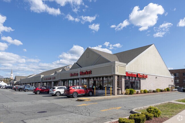
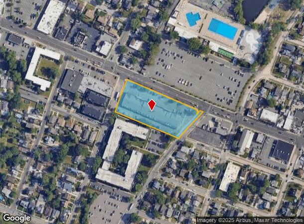
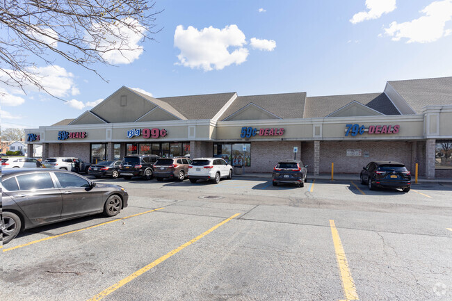
Property Record
130 E Merrick Rd, Valley Stream, NY 11580
NEARBY LISTINGS FOR SALE OR LEASE
Property Detail
130 E Merrick Rd
2035-37-335-00-0002-0
2,101(3),201(3,4),304,404,407
Regionalshoppingcenterormallwithanchorstore
Nassau
AE
New York
36059C0212G
2
2025
2.09 AC
2025
Southern Nassau
410800
Long Island (New York)
27,850 SF
Nassau County-Suffolk County, NY
DEMOGRAPHICS near 130 E Merrick Rd
1 Mile
3 Mile
5 Mile
2024 Total Population
29,954
265,227
688,494
2029 Population
29,105
254,170
655,146
Pop Growth 2024-2029
(2.83%)
(4.17%)
(4.84%)
Average Age
41
41
41
2024 Total Households
9,361
83,234
215,634
HH Growth 2024-2029
(2.96%)
(4.37%)
(5.04%)
Median Household Inc
$110,074
$117,092
$103,629
Avg Household Size
3.10
3.10
3.10
2024 Avg HH Vehicles
2.00
2.00
2.00
Median Home Value
$566,486
$637,509
$654,495
Median Year Built
1949
1952
1951
Nearby Places
- Restaurants
- Banks
- Shops
- Fitness
- Groceries
PUBLIC TRANSPORTATION
COMMUTER RAIL
Valley Stream Station (Far Rockaway Branch - Long Island Rail Road, Long Beach Branch - Long Island Rail Road, West Hempstead Branch - Long Island Rail Road)
DRIVE
WALK
Distance
Valley Stream Station (Far Rockaway Branch - Long Island Rail Road, Long Beach Branch - Long Island Rail Road, West Hempstead Branch - Long Island Rail Road)
2 min
7 min
0.4 mi
Gibson Station (Far Rockaway Branch - Long Island Rail Road)
DRIVE
WALK
Distance
Gibson Station (Far Rockaway Branch - Long Island Rail Road)
4 min
1.7 mi
AIRPORT
John F Kennedy International
DRIVE
WALK
Distance
John F Kennedy International
13 min
7.2 mi
LaGuardia
DRIVE
WALK
Distance
LaGuardia
23 min
14.1 mi
Newark Liberty International
DRIVE
WALK
Distance
Newark Liberty International
50 min
33.9 mi
Freight Ports
NY - Red Hook Container Terminal
DRIVE
WALK
Distance
NY - Red Hook Container Terminal
34 min
18.6 mi
SALE & LEASE HISTORY
LISTING DATE
SALE/LEASE

Oct 09, 2018
For Lease
May 27, 2021
For Lease
Nearby Properties
Address
Land Use
TOTAL SIZE
Lot Size
Zoning
Address
Land Use
TOTAL SIZE
Lot Size
Zoning
285,170 SF
12.63 AC
R3-1
Address
Land Use
TOTAL SIZE
Lot Size
Zoning
27.23 AC
PARK
Address
Land Use
TOTAL SIZE
Lot Size
Zoning
129,378 SF
4.86 AC
R2A
Address
Land Use
TOTAL SIZE
Lot Size
Zoning
160,000 SF
4.02 AC
R3-2
Address
Land Use
TOTAL SIZE
Lot Size
Zoning
64,618 SF
8.04 AC
Address
Land Use
TOTAL SIZE
Lot Size
Zoning
93.35 AC
PARK
Address
Land Use
TOTAL SIZE
Lot Size
Zoning
178,870 SF
7.60 AC
M1-1
Address
Land Use
TOTAL SIZE
Lot Size
Zoning
122,080 SF
2.81 AC
R2
Address
Land Use
TOTAL SIZE
Lot Size
Zoning
5,296 SF
37.42 AC
PARK
Address
Land Use
TOTAL SIZE
Lot Size
Zoning
213,338 SF
2.91 AC
R3X
Address
Land Use
TOTAL SIZE
Lot Size
Zoning
97,190 SF
1.75 AC
R3X
Address
Land Use
TOTAL SIZE
Lot Size
Zoning
78,380 SF
0.85 AC
R3-2
Address
Land Use
TOTAL SIZE
Lot Size
Zoning
806 SF
84.15 AC
R2A
Address
Land Use
TOTAL SIZE
Lot Size
Zoning
260,000 SF
4.14 AC
R2
Address
Land Use
TOTAL SIZE
Lot Size
Zoning
96,071 SF
5.58 AC
M1-1
Address
Land Use
TOTAL SIZE
Lot Size
Zoning
149,804 SF
9.07 AC
M1-1
Address
Land Use
TOTAL SIZE
Lot Size
Zoning
141,782 SF
7.39 AC
M1-1
Address
Land Use
TOTAL SIZE
Lot Size
Zoning
85,330 SF
2.91 AC
R3-2
Address
Land Use
TOTAL SIZE
Lot Size
Zoning
4,000 SF
23.88 AC
PARK
Address
Land Use
TOTAL SIZE
Lot Size
Zoning
131,000 SF
2.43 AC
M1-1
Address
Land Use
TOTAL SIZE
Lot Size
Zoning
107,762 SF
5.23 AC
M1-1
Address
Land Use
TOTAL SIZE
Lot Size
Zoning
59,963 SF
1.55 AC
M1-1
Address
Land Use
TOTAL SIZE
Lot Size
Zoning
78,944 SF
11.31 AC
M1-1
Address
Land Use
TOTAL SIZE
Lot Size
Zoning
53,100 SF
1.38 AC
R2
Address
Land Use
TOTAL SIZE
Lot Size
Zoning
73,300 SF
1.93 AC
R2
Address
Land Use
TOTAL SIZE
Lot Size
Zoning
55,392 SF
1.71 AC
R3-1
Address
Land Use
TOTAL SIZE
Lot Size
Zoning
41,712 SF
0.51 AC
R2A
Address
Land Use
TOTAL SIZE
Lot Size
Zoning
108,350 SF
4.88 AC
R3-2
Address
Land Use
TOTAL SIZE
Lot Size
Zoning
79,200 SF
2.30 AC
R2A
Address
Land Use
TOTAL SIZE
Lot Size
Zoning
79,750 SF
2.66 AC
R3A
The World's #1 Commercial Real Estate Marketplace
Connect with us
© 2025 CoStar Group
The information above has been obtained from sources believed reliable. While we do not doubt its accuracy we have not verified it and make no guarantee, warranty or representation about it. It is your responsibility to independently confirm its accuracy and completeness. Any projections, opinions, assumptions, or estimates used are for example only and do not represent the current or future performance of the property. The value of this transaction to you depends on tax and other factors which should be evaluated by your tax, financial, and legal advisors. You and your advisors should conduct a careful, independent investigation of the property to determine to your satisfaction the suitability of the property for your needs.